 |
| Let's go exploring, buddy! (art courtesy of one of my players! Check her out!) |
Bigger! Better! More! How far can we go in generating random areas? The answer, as you might guess, is pretty far.
We're moving a bit beyond the original scope of these generators, but I want to keep going into the country level. Why? Well, it's not like your players are going to stumble upon a country. (In fantasy, anyway. In Sci-Fi, happens all the time.) But using these generators for inspiration when building a continent or country can help you set up what kind of world you have, and can lead to some good exploration-based worldbuilding.
As you might imagine, this generator will be using a slightly different process than the last few.
Instant Settlement: Country
We once again start with a dice pool. However, this time it isn't set at the beginning. The type of dice you use determines the type of country you'll get.
 |
| Our first example roll |
The pool should consist of anywhere from 10 to 30 dice. Use d4s, d6s, d8s, and d10s. If you want a country with diverse terrain or lots of coastlines and water, make the amount of dice per type about equal. If you want to focus on a particular kind of terrain, use primarily those dice.
That may not have made too much sense, but here's a list that will help you understand better:
- d4s correlate to flatlands (deserts, grasslands, tundras)
- d6s correlate to lowlands (swamps, brushland, ice sheets)
- d8s correlate to forested areas (jungles, forests, taigas)
- d10s correlate to highlands (mesas, mountains, glaciers)
The specific type of terrain is determined by latitude. If a country is closer to the equator, flatlands become deserts and highlands become mesas. If the country is closer to the poles, lowlands become ice sheets and forests become taigas. A country might be large enough to span multiple types of terrain.
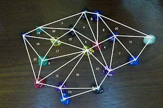
When you roll your dice, connect each die to form triangles. These are regions within the country.
- A region with 2-3 d4s becomes a flatland
- A region with 2-3 d6s becomes a lowland
- A region with 2-3 d8s becomes a forest
- A region with 2-3 d10s becomes a highland
- A region with three different dice becomes a coastline or inland lake.
 |
| Determining the terrain types |
 |
| Making it look prettier |
 |
| Picking out the numbers |
- 3-7: Civilization Hub
- Contains a city, several towns, and dozens of villages
- Trade routes extend into every adjacent region
- Low-level monsters and wild animals roam the area
- Natural resources are common, such as farms, ranching, logging, mining, or hunting
- 8-13: Frontier
- Contains a town and several villages
- Trade routes extend to adjacent hubs and frontiers
- Mid-level monsters make their lairs in these areas, in addition to weaker creatures
- Natural resources are less common
- 14 or more: Untamed Wilds
- Contains a couple hardy villages
- A single trade route extends towards the nearest frontier or hub
- High-level monsters make their lairs here, in addition to weaker creatures
- Natural resources are very difficult to come by
Finally, let's talk about scale. The size of the triangles can vary based on the size of the country, but generally a region is about 100 miles on a side. Pick on of the lines on your map and set that to be 100 miles.
Obviously, for a larger country, you can pick a smaller line. But it's better to increase the size o the country by adding more dice, so that the regions aren't ridiculously large. They will be plenty big even without artificially boosting the size of your map.
 |
| The finished country! |
This example so far was fairly populated, which makes sense since a country is usually ruled over and therefore "claimed". Don't be afraid to make areas of unclaimed wilderness between your established countries. We tend to think of maps as being completely covered in countries, but the history was not that straightforward. A map that has some space between countries becomes an evolving map: which kingdom will claim the mountains first? There's a cool plot hook.
In order to demonstrate the creation method. I've created a couple more examples below.
 |
| Rolling with more d4s and d6s |
 |
| Determining Terrain |
 |
| Topographical map |
 |
| political regions |
 |
| Finished map |
 |
| Rolling with more d8s and d10s |
 |
| Determining Terrain |
 |
| Topography |
 |
| Political regions |
 |
| Finished Map |
I hope this has been interesting and inspiring! If any geologists or earth historians want to tell me how this generator could be improved, I'd love to hear about it.
Thanks for reading!

No comments:
Post a Comment